Walks 4/16 & 4/17/2020

Track 4/16

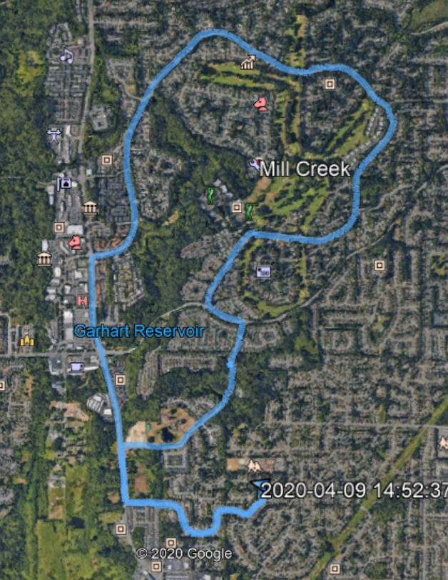
On 4/16 I re-did a walk I did last week where I missed a street. I thought that taking that street would turn a 7 miler into a 9 miler but in fact the extra streets added only .75 miles. But it’s a nice walk, right through the very ritziest heart of Mill Creek. I did get a few stink-eye stares from the locals, who recognized me as an inferior (not a resident of Mill Creek). Tough.

On Friday I took a slightly different route:

Track 4/17

This was only 5.5 miles but also rather pleasant. Not quite so ritzy so I raised no eyebrows.

A little rainy today. Jan has been busily making face masks for healthcare workers at Evergreen Hospital, where she works, but she took a break so we could walk up to the local drug store and get a heat pack for her sore back – sore from many hours hunched over the sewing machine.

The world is crashing down around us. We need to continue the shut-down until the virus is under control and that, I am afraid, will not be until late next year at the earliest. In the meantime we absolutely need the fed gov to step in to support us, coordinate supplies and testing apparatus and strategies – and we have, tragically, an insane authoritarian who claims total authority but no responsibility.

So I guess we can walk until the virus comes for us and takes us, gentle, into that not-so-good night.

Walk 4/14/2020

Track

Of course the major tragedy is the COVID-19 outbreak and our pathetically inadequate federal response. On a personal level, it is an additional bummer because the beautiful weather we have been having lately (all last week, all this week, out as far as they forecast) has been happening at a time when hiking is out of the question.

Bummer.

The walk today was nothing special, in fact it was my usual 4 miler with two hills. But I had never tracked it so here it is on Google Earth.

Walk 4/9/2020

Track

I haven’t been tracking every walk but yesterday I took a different route and almost got it right.

For the first time since we moved here, in 1990, I walked right through the very heart of Mill Creek, the town just north of us. Mill Creek is a pretty ritzy town. It has a very nice little downtown section (now mostly closed); its residences are mostly contained within subdivisions with – if I may say – fairly pretentious names like Heatherstone.

Anyway, I missed the turn I was going to take and wound up with a 7 mile walk rather than the 9 mile walk I was shooting for. But I saw where I went wrong and will correct it next time.

Walk 4/5/2020

Track

I am just documenting some of my newer walks for my own reference. Today’s was only 4.4 miles, I wasn’t exactly sure where I was going so I took a known route. With the track on the map I can look it over and see where there are places I can explore. I see a few possibilities for next week.

Neighborhood Walk 4/4/2020

Pond

Hiking is out – the trails are shut down. Our direction in this state is to only travel short distances and only for essential reasons.

We can go to the doctor or grocery store or drugstore. Jan can go to work (she works at a hospital). But otherwise, if you want to walk, you need to start the walk from your front door and not drive anywhere.

My typical walks around here are 3.5 to 4.5 miles. But starting today, whenever the weather even remotely cooperates, I will be doing something like what I did today, 9.15 miles.

Here is the Google Earth image of my track (I carried my Garmin along):

Track

Our house is the little blue arrow just above the first ‘2’ in ‘2020’. A nice loop.

Here is a little scene that caught my eye:

C. R. Englund and gang signs

I am not a fan of gang graffiti, in general, but with my cheap camera you cannot read what the blue tag says (it says ‘Crips’) but it is kind of a nice splash of color on an otherwise bleak industrial scene.

Also, the truck is a C. R. Englund truck. It reminds me of the hundreds of very early morning (about 4am) walks I used to do in Renton, near where I worked for Boeing, when I used to walk by a place whose lot at that time was filled with C.R. Englund trucks.

This scene:

Wetlands

This little wetlands preservation site is feet from a very busy highway.

The neighborhood walks are no substitute for hiking on forested mountains – oh! how I miss them, particularly now with the snows starting to retreat in the back country – but they are better than nothing.

Squak Mt./Central Peak 3/21/2020

Looking Down on a Babbling Brook

I hiked Squak Mountain today, solo, got onto the trail about 7:45. Five cars in the lot at that time but when I got back the lot was jammed out to the street. The three trailheads I passed on the way to the freeway were all in the same shape.

It seems that the great outdoors is very attractive on a beautiful spring day – Love in the Time of Cholera, so to speak.

No huge deal but a nice hike. I did Tolt Pipeline last Sunday and Monday but didn’t blog it. Not big enough to blog every time.

I am going to go somewhere tomorrow as well.

Here is the Bullitt Fireplace:

Made in Happier Times

Tolt Pipeline Trail 3/4/2020

Heart Attack Hill?

I hiked the Tolt Pipeline Trail today. The out-and-back route I take is about 7 miles. There is a sharp hill less than a mile from the parking lot known locally as Heart Attack Hill.

Well, my cheap camera and poor camera skills make this long and very steep hill look almost flat. Go figure. But if you imagine the photo above as being almost straight up, well that is how it looks in the flesh so to speak.

The trail itself is actually a road (although only official vehicles are allowed access) and the road runs through a fairly ritzy rural neighborhood. The houses are nice and quite a few have horses. Here is a typical scene:

Rural Living

On the way back I stood at the top of Heart Attack Hill and looked down and out:

Looking Down

Days are getting longer and the hiking season is starting to ramp up.

I look forward to welcoming our niece Jaclyn and her dog (a Labradoodle) in June. Her husband is in the military and he is being sent to an overseas location where family is not allowed to come along. Kind of nasty for the service members and their families but we will have a great addition to our household for the summer.

Both Jaclyn and the dog are hikers….

Raging River State Forest 2/21/2020

The Raging Forest

This sounds like a new hike but it is just Rattlesnake Mountain. Hiked today with Ken, Mark, Mike, Greg and John.

The Rattlesnake Mountain Trail is still the Rattlesnake etc. trail, but ever since they finished putting in all the mountain bike trails there are signs advertising the area as Raging River State Forest.

I am not sure I have ever seen any rivers in the immediate area raging, but I must not be hiking in the right place.

At one point, there were three signs pointing out where to go:

Questions?

This is the same hike I did with Carl a couple of weeks ago. 8 mile up and down, about 2K elevation gain, not a lot of views on the way (and none today, it was rainy) but plenty of awesome forest and it is a fun workout.

It is not a killer hike but it is a much better workout than my typical hour on the treadmill or 5 mile neighborhood walk.

More rain forecast next week but spring is on the way.

Sammamish River Trail 2/12/2020

RR Bridge

I did something a little different today.

I parked at the Woodinville Sports Field parking lot intending to do my usual Tolt Pipe Line hike. That hike starts on the Sammamish River Trail and, after only a few hundred yards on the river trail you intersect the pipe line trail. Today, when I got to the pipe line trail I walked a short way to get a closer look at a couple of horses:

Horses

But then, just to be different, I turned around and went back to the river trail. I am glad I did.

This trail is pretty flat and (not surprisingly) runs along the side of the river for miles and miles. I determined to walk an hour and then turn around. It was so much fun I extended it to an hour and a half, making this a nice 3-hour walk.

Plenty of things to see along the way. A little snail, for example. Finally someone I can outpace:

Snail on the Trail

I silently wished this little creature good luck, as there are a lot of bicyclists zooming by, and it would be easy to run it over.

There were various river scenes:

River Living
The River

Next time I do this walk I will bring the Garmin to map it out and see how long it is. 90 minutes each way, I am guessing about nine miles out and back?

Anyway, it was a fun walk. Rain back in the forecast starting tonight but I take my opportunities when they appear.

Tiger Mountain/Nook 2/9/2020

The Bus Trail’s Bus

Two days in a row with no rain, two days in a row hiking. Not a coincidence.

Mike and Ken and I got out this morning for a little Tiger Mountain jaunt. The loop we did was similar to the loop I often do solo, but we went up (rather than down) the Wetlands Trail and up (rather than down) the Nook Trail. Down (rather than up) the Section Line and so on.

About 5 miles, great workout. Here is the track:

Track